
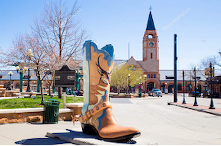
Aurora Colorado
Sightseeing
Rocky Mountain Arsenal National Wildlife Refuge! Located just 10 miles northeast of downtown Denver, you can step into nature and see the native wildlife that call the Refuge home. Bison, deer, raptors, songbirds, waterfowl, prairie dogs, and coyotes. Discover all that Rocky Mountain Arsenal National Wildlife Refuge has to offer and best of all it's FREE to visit!
90 (рекомендации местных жителей)
Национальный заповедник дикой природы Rocky Mountain Arsenal
6550 Gateway RoadRocky Mountain Arsenal National Wildlife Refuge! Located just 10 miles northeast of downtown Denver, you can step into nature and see the native wildlife that call the Refuge home. Bison, deer, raptors, songbirds, waterfowl, prairie dogs, and coyotes. Discover all that Rocky Mountain Arsenal National Wildlife Refuge has to offer and best of all it's FREE to visit!
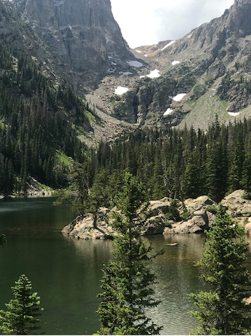
Probably the most popular scenic drives near Denver is Mount Evans Scenic Byway. This road is the highest paved road in the USA, so you’re sure to get some incredible views on this drive. The Mount Evans Scenic Byway reaches 14,264 feet above sea level in 28 miles, so you’ll be in a prime position to get some amazing photographs! This scenic drive has plenty of winding curves, so it’s actually a very exciting drive. It’s worth noting that Mount Evans is one of Colorado’s “fourteeners” (in other words, a mountain peak that reaches at least 14,000 feet), so if you’re looking to mark them off one by one, this is the perfect way to do so. You might even spot some mountain goats or sheep. If you’ve ever wanted to see an original water wheel, the 1893 Charlie Tayler Water Wheel is located along the route of this drive.
Allow time to explore Idaho Springs. If you have a 4-wheel drive vehicle, drive the OMG Road between Idaho Springs and Central City. This short drive takes you past old mines and an old Ghost town.
259 (рекомендации местных жителей)
Гора Эванс
Probably the most popular scenic drives near Denver is Mount Evans Scenic Byway. This road is the highest paved road in the USA, so you’re sure to get some incredible views on this drive. The Mount Evans Scenic Byway reaches 14,264 feet above sea level in 28 miles, so you’ll be in a prime position to get some amazing photographs! This scenic drive has plenty of winding curves, so it’s actually a very exciting drive. It’s worth noting that Mount Evans is one of Colorado’s “fourteeners” (in other words, a mountain peak that reaches at least 14,000 feet), so if you’re looking to mark them off one by one, this is the perfect way to do so. You might even spot some mountain goats or sheep. If you’ve ever wanted to see an original water wheel, the 1893 Charlie Tayler Water Wheel is located along the route of this drive.
Allow time to explore Idaho Springs. If you have a 4-wheel drive vehicle, drive the OMG Road between Idaho Springs and Central City. This short drive takes you past old mines and an old Ghost town.
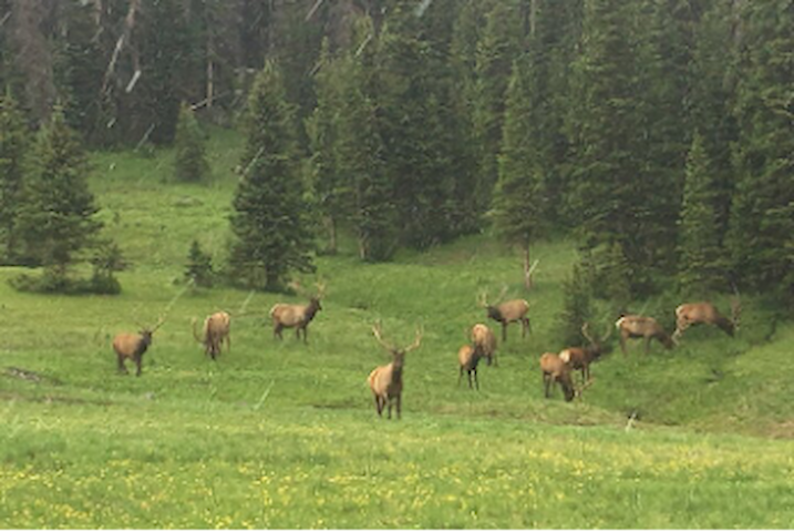
Celebrate Estes Park's resident elk at this family-friendly festival in Bond Park (170 MacGregor Ave). Enjoy vendors, live music, food trucks, bugling contests, performances and more at this year's Elk Fest! The festival coincides with the famous elk rut, or elk mating season. Wild elk are often easily seen in town and in nearby Rocky Mountain National Park.
A lot of fun and adventure happens at higher altitudes - Take Estes Park, Colorado, which sits at an elevation of 7,522 feet. It’s located just outside Rocky Mountain National Park, one of the highest national parks in the U.S., where you’ll find Trail Ridge Road, the highest continuous paved road in Colorado. It’s a place where snow-capped mountains pierce impossibly blue skies, seemingly barren alpine tundra is dotted with hardy wildflowers, and mountain streams cascade down from high peaks.
Altitude sickness can ruin a good day at its best and turn it deadly at its worst. Fortunately, it’s rare that anyone will get true altitude sickness in Estes Park. But it is high enough that if you’re visiting from sea level, it’s worth paying attention.
The crisp, mountain air; charming shops; and dozens of outdoors activities make this a four-season destination. Inside the village, you can stroll the Riverwalk, cast a line in Fall River, or make a stop for ice cream. Peaks rise all around, from 8,500 feet to more than 14,000 feet, rendering gorgeous views in every direction. In the warmer months, head to one of many nearby patios to enjoy those panoramas, good food and a locally-made wine. When the temperatures drop, move indoors, tucking into a table near a roaring fire to savor wild game, delicious ethnic dishes or maybe a hearty steak. Shops and galleries present a variety that spins from practical to whimsical. Wildlife is still so plentiful that the elk wandering downtown seem like the official welcoming committee. Indeed, guests are as likely to run into an elk as one of the many artists who find inspiration here. Painters often set up on the sidewalks, in parks or along the river. Other artists work in galleries or studios, shaping bronze into animals or blowing glass into exquisite bowls.
The Stanley Hotel was built in 1909 by F.O. Stanley (known for the Stanley Steamer) as an upscale resort and wellness destination. The Stanley also has plenty of pop-culture history. Stephen King spent one winter night there snowed in, and was inspired to write “The Shining.” As the inspiration for a spooky movie like The Shining, the Stanley has earned a bit of a paranormal reputation. You can now go on night tour at the property to explore the active phenomena and spirit folklore. If you’re more interested in the history and celebrities who have stayed over the years, they offer a daytime tour as well. The Stanley is more than just a hotel. It’s internationally known for an expansive whiskey bar, home to Colorado’s largest selection of whiskeys and single malt selections. Plus, restaurants, gift shops, and event spaces.
Gain a bird's-eye view of Estes Park without having to hike! The Estes Park Aerial Tram safely whisks you above the treetops to the summit of Prospect Mountain. Operating daily from the end of May to early September, the tram is one of the few European-style cable cars operating in the United States. Instead of using towers to support the wires, the tram, built and designed by Robert Heron, travels across a free span of wires strung between top and bottom stations.
May 28, 2022 - September 5, 2022 - Open daily from 9 a.m. to 6 p.m.; September 6, 2022 - September 25, 2022 - Open Saturday and Sunday only from 9 a.m. to 6 p.m. Adult tickets are $16; Seniors (60+) tickets are $14; Kids(6-11) tickets are $10; Tickets for kids 5 & under are FREE
586 (рекомендации местных жителей)
Estes Park
Celebrate Estes Park's resident elk at this family-friendly festival in Bond Park (170 MacGregor Ave). Enjoy vendors, live music, food trucks, bugling contests, performances and more at this year's Elk Fest! The festival coincides with the famous elk rut, or elk mating season. Wild elk are often easily seen in town and in nearby Rocky Mountain National Park.
A lot of fun and adventure happens at higher altitudes - Take Estes Park, Colorado, which sits at an elevation of 7,522 feet. It’s located just outside Rocky Mountain National Park, one of the highest national parks in the U.S., where you’ll find Trail Ridge Road, the highest continuous paved road in Colorado. It’s a place where snow-capped mountains pierce impossibly blue skies, seemingly barren alpine tundra is dotted with hardy wildflowers, and mountain streams cascade down from high peaks.
Altitude sickness can ruin a good day at its best and turn it deadly at its worst. Fortunately, it’s rare that anyone will get true altitude sickness in Estes Park. But it is high enough that if you’re visiting from sea level, it’s worth paying attention.
The crisp, mountain air; charming shops; and dozens of outdoors activities make this a four-season destination. Inside the village, you can stroll the Riverwalk, cast a line in Fall River, or make a stop for ice cream. Peaks rise all around, from 8,500 feet to more than 14,000 feet, rendering gorgeous views in every direction. In the warmer months, head to one of many nearby patios to enjoy those panoramas, good food and a locally-made wine. When the temperatures drop, move indoors, tucking into a table near a roaring fire to savor wild game, delicious ethnic dishes or maybe a hearty steak. Shops and galleries present a variety that spins from practical to whimsical. Wildlife is still so plentiful that the elk wandering downtown seem like the official welcoming committee. Indeed, guests are as likely to run into an elk as one of the many artists who find inspiration here. Painters often set up on the sidewalks, in parks or along the river. Other artists work in galleries or studios, shaping bronze into animals or blowing glass into exquisite bowls.
The Stanley Hotel was built in 1909 by F.O. Stanley (known for the Stanley Steamer) as an upscale resort and wellness destination. The Stanley also has plenty of pop-culture history. Stephen King spent one winter night there snowed in, and was inspired to write “The Shining.” As the inspiration for a spooky movie like The Shining, the Stanley has earned a bit of a paranormal reputation. You can now go on night tour at the property to explore the active phenomena and spirit folklore. If you’re more interested in the history and celebrities who have stayed over the years, they offer a daytime tour as well. The Stanley is more than just a hotel. It’s internationally known for an expansive whiskey bar, home to Colorado’s largest selection of whiskeys and single malt selections. Plus, restaurants, gift shops, and event spaces.
Gain a bird's-eye view of Estes Park without having to hike! The Estes Park Aerial Tram safely whisks you above the treetops to the summit of Prospect Mountain. Operating daily from the end of May to early September, the tram is one of the few European-style cable cars operating in the United States. Instead of using towers to support the wires, the tram, built and designed by Robert Heron, travels across a free span of wires strung between top and bottom stations.
May 28, 2022 - September 5, 2022 - Open daily from 9 a.m. to 6 p.m.; September 6, 2022 - September 25, 2022 - Open Saturday and Sunday only from 9 a.m. to 6 p.m. Adult tickets are $16; Seniors (60+) tickets are $14; Kids(6-11) tickets are $10; Tickets for kids 5 & under are FREE
Trail Ridge Road is widely known as one of the most famous roads in the USA, with its great road conditions, mountain views, glacier peaks and large valleys. As the highest byway in the United States, it’s registered on the National Register of Historic Places. Trail Ridge Road, Rocky Mountain National Park's heavily traveled highway to the sky, inspired awe before the first motorist ever traveled it.
Begin your journey at Estes Park or Grand Lake, Trail Ridge Road climbs 4,000 feet in a matter of minutes, as it winds across the tundra's vastness to its high point at 12,183 feet elevation. Pikas, marmots, ptarmigans and bighorn sheep are commonly seen. About 200 species of tiny alpine plants hug the ground. The Continental Divide, where stream flows are separated east from west, is crossed at Milner Pass, located at a surprisingly low 10,758 feet elevation. Moose munch greenery in the upper reaches of the Colorado River, which flows through the scenic Kawuneeche Valley. Grazing elk greet sunrise and sunset in many of the forest-rimmed meadows found around the park. This drive brings you to the town of Lulu City. An old mining town that was established in 1880, it’s a great historical pitstop for those interested in the making of America.
7 (рекомендации местных жителей)
Trail Ridge Road
Trail Ridge RoadTrail Ridge Road is widely known as one of the most famous roads in the USA, with its great road conditions, mountain views, glacier peaks and large valleys. As the highest byway in the United States, it’s registered on the National Register of Historic Places. Trail Ridge Road, Rocky Mountain National Park's heavily traveled highway to the sky, inspired awe before the first motorist ever traveled it.
Begin your journey at Estes Park or Grand Lake, Trail Ridge Road climbs 4,000 feet in a matter of minutes, as it winds across the tundra's vastness to its high point at 12,183 feet elevation. Pikas, marmots, ptarmigans and bighorn sheep are commonly seen. About 200 species of tiny alpine plants hug the ground. The Continental Divide, where stream flows are separated east from west, is crossed at Milner Pass, located at a surprisingly low 10,758 feet elevation. Moose munch greenery in the upper reaches of the Colorado River, which flows through the scenic Kawuneeche Valley. Grazing elk greet sunrise and sunset in many of the forest-rimmed meadows found around the park. This drive brings you to the town of Lulu City. An old mining town that was established in 1880, it’s a great historical pitstop for those interested in the making of America.
August 13 (or there abouts), 10 am-4 pm
There will be moose-viewing opportunities, moose talks, a scavenger hunt, fly-fishing class, games, guided hikes, moose biology, brats and burgers. Ender Post Inc. will present scenes from the documentary “Colorado’s Moose” at the State Forest State Park Moose Visitor Center. Admission is free with the purchase of a $7 parking pass.
Государственный лесной парк Штата
56750 CO-14August 13 (or there abouts), 10 am-4 pm
There will be moose-viewing opportunities, moose talks, a scavenger hunt, fly-fishing class, games, guided hikes, moose biology, brats and burgers. Ender Post Inc. will present scenes from the documentary “Colorado’s Moose” at the State Forest State Park Moose Visitor Center. Admission is free with the purchase of a $7 parking pass.
Shortest byway in Colorado, the South Platte River Trail is big in history. It’s located near Nebraska’s border, and was used as a westward route by pioneering traders, fortune seekers and settlers of the 19th century. Covering the entire loop, it features a picturesque view of the South Platte River, and passes the former location of Fort Sedgwick.
This trail is particularly interactive, while driving you’ll pass various placards that detail information about the area and its history. Though this drive is focused on history, you may see some wildlife.
About 150 years ago, the town used to be the sole Pony Express station in the whole of Colorado. This is also where the 15-year-old Buffalo Bill (William Cody) signed in as a rider. Going west of the trail is Fort Sedgwick, which served as an important installation used to protect travelers and telegraph lines from Indians and robbery threats.
Old Ford Garage & Museum at 110 East 1st Street Julesburg. This privately owned collection is located in a structure that began as a car dealership in 1908. It offers vintage automobiles, memorabilia and photographs. Inside, retired barber Lee Kizer displays his personal collection of vintage cars and classic gas pumps, etc. (Open as requested).
Depot Museum-201 West 1st Street, Julesburg. Offers a unique collection of agriculture, archaeology, archives, folklore, glass, history, Indian artifacts, mineralogy, military items, music, natural history and transportation. (Memorial Day to Labor Day).
Fort Sedgwick Museum-114 East 1st Street, Julesburg, offers a unique collection of historic radios, photographs and temporary displays
20 (рекомендации местных жителей)
South Platte River Trail
South Platte River TrailShortest byway in Colorado, the South Platte River Trail is big in history. It’s located near Nebraska’s border, and was used as a westward route by pioneering traders, fortune seekers and settlers of the 19th century. Covering the entire loop, it features a picturesque view of the South Platte River, and passes the former location of Fort Sedgwick.
This trail is particularly interactive, while driving you’ll pass various placards that detail information about the area and its history. Though this drive is focused on history, you may see some wildlife.
About 150 years ago, the town used to be the sole Pony Express station in the whole of Colorado. This is also where the 15-year-old Buffalo Bill (William Cody) signed in as a rider. Going west of the trail is Fort Sedgwick, which served as an important installation used to protect travelers and telegraph lines from Indians and robbery threats.
Old Ford Garage & Museum at 110 East 1st Street Julesburg. This privately owned collection is located in a structure that began as a car dealership in 1908. It offers vintage automobiles, memorabilia and photographs. Inside, retired barber Lee Kizer displays his personal collection of vintage cars and classic gas pumps, etc. (Open as requested).
Depot Museum-201 West 1st Street, Julesburg. Offers a unique collection of agriculture, archaeology, archives, folklore, glass, history, Indian artifacts, mineralogy, military items, music, natural history and transportation. (Memorial Day to Labor Day).
Fort Sedgwick Museum-114 East 1st Street, Julesburg, offers a unique collection of historic radios, photographs and temporary displays
The byway showcases the two highest peaks of the Rocky Mountains: Mount Elbert at elevation 14,440 feet and Mount Massive at elevation 14,428 feet. The byway connects with the Collegiate Peaks Scenic Byway at the junction of Colorado State Highway 82 and U.S. Highway 24. Starting near the Arkansas River and passing through several towns and scenic highlights, this is a great drive for those wishing to take in Colorado’s natural beauty.
A major highlight of this drive is that it passes through Leadville. A quaint historical town well worth a pitstop. It is the highest incorporated town in the United States, at 10,152 feet. In the 1880’s it was a boomtown with its silver mines. In the 19th Century, millions of dollars in gold and silver were mined in central Colorado. The Leadville area was home to many of the big names of mining, such as Horace Tabor and his wife "Baby Doe," and J.J. and (the Unsinkable) Molly Brown. Though fire or other natural disasters have destroyed many of the once booming mining towns, both Leadville and Twin Lakes still stand today as centers of mining.
The Top of the Rockies Byway travels through Aspen, Leadville and to either Minturn or Copper Mountain, literally at the Top of the Rockies. The road seldom drops below 9,000 feet along the Top of the Rockies byway. Mt. Elbert and Mt. Massive the two highest points in Colorado, are visible from the byway. You can also drive over Tennessee Pass or Freemont Pass, each over 10,000 feet. The Top of the Rockies byway also runs through three National Forests - Pike National Forest, San Isabel National Forest and the White River National Forest. The Camp Hale Memorial is also along the byway. Here, soldiers trained on skis to fight in the Apennine Mountains of Italy during World War II. Standing there now is a memorial commemorating their service. Nearby, the Tabor Opera House stands as a memory of the mining boom. Horace Tabor built the theater in 1879 in 100 days for $40,000. The house has welcomed many well-known personalities over the years including Houdini, John Philip Sousa, Oscar Wilde, and Anna Held. Today, visitors can enjoy the preserved Opera House.
Top of the Rockies Scenic Byway sign
The byway showcases the two highest peaks of the Rocky Mountains: Mount Elbert at elevation 14,440 feet and Mount Massive at elevation 14,428 feet. The byway connects with the Collegiate Peaks Scenic Byway at the junction of Colorado State Highway 82 and U.S. Highway 24. Starting near the Arkansas River and passing through several towns and scenic highlights, this is a great drive for those wishing to take in Colorado’s natural beauty.
A major highlight of this drive is that it passes through Leadville. A quaint historical town well worth a pitstop. It is the highest incorporated town in the United States, at 10,152 feet. In the 1880’s it was a boomtown with its silver mines. In the 19th Century, millions of dollars in gold and silver were mined in central Colorado. The Leadville area was home to many of the big names of mining, such as Horace Tabor and his wife "Baby Doe," and J.J. and (the Unsinkable) Molly Brown. Though fire or other natural disasters have destroyed many of the once booming mining towns, both Leadville and Twin Lakes still stand today as centers of mining.
The Top of the Rockies Byway travels through Aspen, Leadville and to either Minturn or Copper Mountain, literally at the Top of the Rockies. The road seldom drops below 9,000 feet along the Top of the Rockies byway. Mt. Elbert and Mt. Massive the two highest points in Colorado, are visible from the byway. You can also drive over Tennessee Pass or Freemont Pass, each over 10,000 feet. The Top of the Rockies byway also runs through three National Forests - Pike National Forest, San Isabel National Forest and the White River National Forest. The Camp Hale Memorial is also along the byway. Here, soldiers trained on skis to fight in the Apennine Mountains of Italy during World War II. Standing there now is a memorial commemorating their service. Nearby, the Tabor Opera House stands as a memory of the mining boom. Horace Tabor built the theater in 1879 in 100 days for $40,000. The house has welcomed many well-known personalities over the years including Houdini, John Philip Sousa, Oscar Wilde, and Anna Held. Today, visitors can enjoy the preserved Opera House.
A former burro trail, the now-paved Guanella Pass byway climbs to timberline, taking in spectacular views of Mount Bierstadt, Mount Evans and the alpine tundra before descending into cool groves of aspen and pine that light up with brilliant golden hues in autumn.
The area around the byway was once used for logging and mining, and one of Colorado’s earliest silver rushes was in Georgetown and Silver Plume. These are two of the state’s best-preserved Victorian towns. Georgetown’s Gateway Visitor Center has wonderful interpretive displays and films. The centerpiece of Georgetown's historic district is the Hamill House Museum. As a meticulously preserved example of late-1800s residential living, the house offers an extraordinary opportunity to see the architectural styles, furnishings and landscaping techniques of the day. As part of an expansion to the house in 1879, a magnificent conservatory was added. Be captivated by the splendor of the indoor garden. One of the town’s must-sees is the Hotel de Paris Museum, which paints a vivid portrait of the luxury that the silver boom afforded and chronicles the dramatic life story of the former hotel’s founder.
Stop at Georgetown Wildlife Watching Area for a glimpse of the hundreds of bighorn sheep in the area.
Depart south on Guanella Pass Road to begin the climb up toward the 11,669-foot mountain pass. The drive (and traffic) will be especially splendid in September and October, as changing leaves light up the path. Before the top of the pass, you can turn off to the Silver Dale Interpretive Site area, a protected district of the former townsite and several trails. Wind through scenic aspen forest and among waterfalls to see the remains of the Colorado Central Mill. Drive a few minutes further up the byway to another sign for Silver Dale to find remnants of a building that's also part of the ghost town.
Events on the calendar: Georgetown House Tour (Apr), Silver Plume Melodrama (Apr), Oktoberfest on the Georgetown Loop Railroad, Georgetown Bighorn Sheep Festival (Nov).
72 (рекомендации местных жителей)
Guanella Pass
A former burro trail, the now-paved Guanella Pass byway climbs to timberline, taking in spectacular views of Mount Bierstadt, Mount Evans and the alpine tundra before descending into cool groves of aspen and pine that light up with brilliant golden hues in autumn.
The area around the byway was once used for logging and mining, and one of Colorado’s earliest silver rushes was in Georgetown and Silver Plume. These are two of the state’s best-preserved Victorian towns. Georgetown’s Gateway Visitor Center has wonderful interpretive displays and films. The centerpiece of Georgetown's historic district is the Hamill House Museum. As a meticulously preserved example of late-1800s residential living, the house offers an extraordinary opportunity to see the architectural styles, furnishings and landscaping techniques of the day. As part of an expansion to the house in 1879, a magnificent conservatory was added. Be captivated by the splendor of the indoor garden. One of the town’s must-sees is the Hotel de Paris Museum, which paints a vivid portrait of the luxury that the silver boom afforded and chronicles the dramatic life story of the former hotel’s founder.
Stop at Georgetown Wildlife Watching Area for a glimpse of the hundreds of bighorn sheep in the area.
Depart south on Guanella Pass Road to begin the climb up toward the 11,669-foot mountain pass. The drive (and traffic) will be especially splendid in September and October, as changing leaves light up the path. Before the top of the pass, you can turn off to the Silver Dale Interpretive Site area, a protected district of the former townsite and several trails. Wind through scenic aspen forest and among waterfalls to see the remains of the Colorado Central Mill. Drive a few minutes further up the byway to another sign for Silver Dale to find remnants of a building that's also part of the ghost town.
Events on the calendar: Georgetown House Tour (Apr), Silver Plume Melodrama (Apr), Oktoberfest on the Georgetown Loop Railroad, Georgetown Bighorn Sheep Festival (Nov).
Open: Memorial Day - Thanksgiving
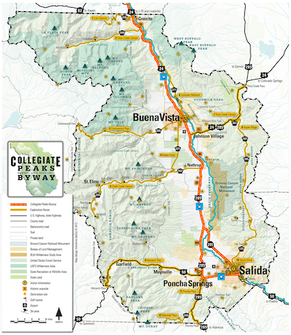
Explore Colorado’s grand Collegiate Peaks, fourteeners with names like Mount Princeton, Mount Yale and Mount Harvard; start your drive in Salida, about an hour south of Leadville for the Collegiate Peaks byway. Discover the heart of Colorado where prairies sweep up from the Arkansas River’s famous whitewater canyons to dramatic 14,000-foot peaks. This 57-mile byway takes you to America’s Continental Divide where the Rockies get real. The Upper Arkansas Valley is renowned for its whitewater fun, trout fishing, wildlife, bird-watching and more 14,000-foot peaks than anywhere else in America. Folks of all skill and fitness levels come for an abundance of hiking and biking on pine-scented trails. And the powder light snow is perfect for winter sports. Snow-capped Fourteener peaks, wildflowers, golden aspen, 300 days of sun and rich history await you.
8 (рекомендации местных жителей)
Collegiate Peaks
Open: Memorial Day - Thanksgiving
Explore Colorado’s grand Collegiate Peaks, fourteeners with names like Mount Princeton, Mount Yale and Mount Harvard; start your drive in Salida, about an hour south of Leadville for the Collegiate Peaks byway. Discover the heart of Colorado where prairies sweep up from the Arkansas River’s famous whitewater canyons to dramatic 14,000-foot peaks. This 57-mile byway takes you to America’s Continental Divide where the Rockies get real. The Upper Arkansas Valley is renowned for its whitewater fun, trout fishing, wildlife, bird-watching and more 14,000-foot peaks than anywhere else in America. Folks of all skill and fitness levels come for an abundance of hiking and biking on pine-scented trails. And the powder light snow is perfect for winter sports. Snow-capped Fourteener peaks, wildflowers, golden aspen, 300 days of sun and rich history await you.
Driving Directions: Begins as CO Highway 7 in Estes Park, passes Lily Mountain and Twin Sisters, then turns south just past Allenspark on CO Highway 72, goes to Nederland where it continues south on CO Highway 119, through Blackhawk, through Clear Creek Canyon and down to I-70
Established over 100 years ago, this is Colorado’s first scenic byway. It’s a lovely drive, passing interesting sites and places along the way, and makes a great day trip from Estes Park. This drive is relatively winding but is also leisurely and can be combined with elk watching in Estes Park. On this drive, you see Longs Peak, the tallest peak in Rocky Mountain National Park and Mt. Meeker at 13,911. St. Malo’s Chapel, built on a rocky outcrop, stands majestic in front of Mt. Meeker. Gravel roads crossing the main highway lead to ghost towns at Hesse and Apex; others lead to high country lakes. There are many aspen stands mixed in with evergreens. On a clear fall day, these golden trees set against the high peaks shine in the sun. One of the best pitstops you can make is to visit the beautiful Saint Catherine of Siena Chapel in Allenspark. A functioning Catholic chapel and tourist attraction, it’s a beautiful and unique landmark that shouldn’t be missed.
10 (рекомендации местных жителей)
Peak to Peak Highway
Peak to Peak HighwayDriving Directions: Begins as CO Highway 7 in Estes Park, passes Lily Mountain and Twin Sisters, then turns south just past Allenspark on CO Highway 72, goes to Nederland where it continues south on CO Highway 119, through Blackhawk, through Clear Creek Canyon and down to I-70
Established over 100 years ago, this is Colorado’s first scenic byway. It’s a lovely drive, passing interesting sites and places along the way, and makes a great day trip from Estes Park. This drive is relatively winding but is also leisurely and can be combined with elk watching in Estes Park. On this drive, you see Longs Peak, the tallest peak in Rocky Mountain National Park and Mt. Meeker at 13,911. St. Malo’s Chapel, built on a rocky outcrop, stands majestic in front of Mt. Meeker. Gravel roads crossing the main highway lead to ghost towns at Hesse and Apex; others lead to high country lakes. There are many aspen stands mixed in with evergreens. On a clear fall day, these golden trees set against the high peaks shine in the sun. One of the best pitstops you can make is to visit the beautiful Saint Catherine of Siena Chapel in Allenspark. A functioning Catholic chapel and tourist attraction, it’s a beautiful and unique landmark that shouldn’t be missed.
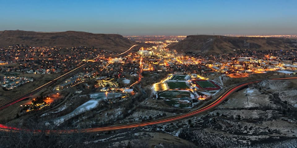
If you’re after a bird’s eye view of Denver, Golden or Boulder, then this drive is the perfect way to achieve that goal. Less than half an hour from Denver’s bustling downtown area, this is a great drive for those looking to fit some escapism into their city trip. Accessing the summit of Lookout Mountain from Golden is a quick 20-minute drive that happens to be on one of the most scenic routes along the Front Range. It’s part of the Lariat Loop, a national scenic byway connecting Golden with Evergreen and Morrison.
9 (рекомендации местных жителей)
Lookout Mountain Road
Lookout Mountain RoadIf you’re after a bird’s eye view of Denver, Golden or Boulder, then this drive is the perfect way to achieve that goal. Less than half an hour from Denver’s bustling downtown area, this is a great drive for those looking to fit some escapism into their city trip. Accessing the summit of Lookout Mountain from Golden is a quick 20-minute drive that happens to be on one of the most scenic routes along the Front Range. It’s part of the Lariat Loop, a national scenic byway connecting Golden with Evergreen and Morrison.
Start off driving up to the top of Lookout Mountain. Pull over a couple of places along the way to view the plains spreading off to the east. Make sure one of your stops is Windy Saddle where you can see the plains to the east and the towering Rockies to the west. Then continue on up to the Lookout Mountain Nature Center where you can learn about the flora and fauna of the area and enjoy some really spectacular views. Buffalo Bill's grave and memorial museum both lie atop the mountain. The museum offers a glimpse into the life of William F. Cody, buffalo hunter extraordinaire and star of the Wild West Show.
Learn about Adolf Coors and family as they built one of America’s favorite brands. See how the beer is made and stop at the end for a couple of the freshest beers you’ll ever try. Continue your trip just outside of Golden at the Colorado Railroad Museum. Travel back in time on the Galloping Goose (runs every Saturday), tour the museum, see restorations in progress, check out the model trains from the basement of the museum to the larger ones in the track outside. This hands-on museum lets you climb in all the full-size trains from yesteryear.
Next on the agenda is one of the premier concert venues not just in Colorado but in the world! Red Rocks Amphitheatre could easily be a full day in itself. Walk up and down the stairs, test the awesome acoustics and enjoy the fresh mountain air and stunning views.
Leave the Loop at the Humphrey History Park and Museum. The 35-acre Ranch has tours of the Humphrey\'s unique home and hands-on activity stations scattered throughout the Ranch that allows visitors to step back in time. Visit with the goats, chickens and ranch cats, play croquet, horseshoes, hike, chop some wood, or just swing on an old-fashioned rope swing.
Spend some time at Evergreen’s historic Hiwan Homestead Museum where you’ll see how people lived in turn-of-the-century (1890’s – 1930’s) Colorado. This log cabin (much more than a small cabin though) provides a glimpse of how early settlers escaped the Denver heat in this mountain retreat. Venture back outdoors in Evergreen at the Evergreen Lake House and Park. Walk by the cool waters of Evergreen Lake. Enjoy nature in a beautiful mountain setting. Enjoy the serenity.
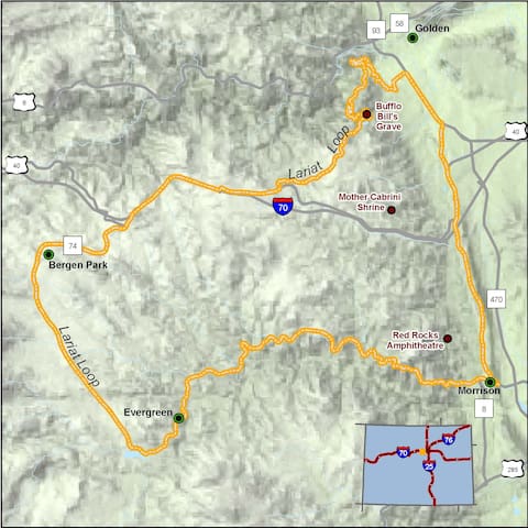
Lariat Loop Road
Lariat Loop RoadStart off driving up to the top of Lookout Mountain. Pull over a couple of places along the way to view the plains spreading off to the east. Make sure one of your stops is Windy Saddle where you can see the plains to the east and the towering Rockies to the west. Then continue on up to the Lookout Mountain Nature Center where you can learn about the flora and fauna of the area and enjoy some really spectacular views. Buffalo Bill's grave and memorial museum both lie atop the mountain. The museum offers a glimpse into the life of William F. Cody, buffalo hunter extraordinaire and star of the Wild West Show.
Learn about Adolf Coors and family as they built one of America’s favorite brands. See how the beer is made and stop at the end for a couple of the freshest beers you’ll ever try. Continue your trip just outside of Golden at the Colorado Railroad Museum. Travel back in time on the Galloping Goose (runs every Saturday), tour the museum, see restorations in progress, check out the model trains from the basement of the museum to the larger ones in the track outside. This hands-on museum lets you climb in all the full-size trains from yesteryear.
Next on the agenda is one of the premier concert venues not just in Colorado but in the world! Red Rocks Amphitheatre could easily be a full day in itself. Walk up and down the stairs, test the awesome acoustics and enjoy the fresh mountain air and stunning views.
Leave the Loop at the Humphrey History Park and Museum. The 35-acre Ranch has tours of the Humphrey\'s unique home and hands-on activity stations scattered throughout the Ranch that allows visitors to step back in time. Visit with the goats, chickens and ranch cats, play croquet, horseshoes, hike, chop some wood, or just swing on an old-fashioned rope swing.
Spend some time at Evergreen’s historic Hiwan Homestead Museum where you’ll see how people lived in turn-of-the-century (1890’s – 1930’s) Colorado. This log cabin (much more than a small cabin though) provides a glimpse of how early settlers escaped the Denver heat in this mountain retreat. Venture back outdoors in Evergreen at the Evergreen Lake House and Park. Walk by the cool waters of Evergreen Lake. Enjoy nature in a beautiful mountain setting. Enjoy the serenity.
Directions: Simply get off I-70 before the Eisenhower Tunnel (coming from the east) and go over Loveland Pass instead.
You’ll be greeted with epic views of the Continental Divide and many of the best peaks in the Front Range.
Loveland Pass Road, which is now along US Highway Route 6, was officially adopted by the US Highway system and connected to the town of Silver Plume in 1919. The pass was the main vehicular means of transportation between Denver and Georgetown until the Eisenhower Tunnel opened in 1973.
Steep grades and tough weather conditions have made it the location for many unfortunate events throughout the past few decades. In addition to semi-frequent vehicle accidents, Loveland pass suffered a deadly avalanche in 2013. It’s accessed via US Route 6, which reconnects with Interstate 70 at exit 205 on the west side in the town of Silverthorne. Bicyclists, pedestrians, and trucks carrying hazardous materials must travel over Loveland Pass, as they are not permitted in the Eisenhower Tunnel.
Seasonality – Loveland Pass is considered treacherous in the winter, but attracts many visitors and remains open year-round. However, the road is subject to frequent temporary closure during inclimate weather conditions.
Vehicle Restrictions – Chain restrictions are often imposed in the winter months. 2WD vehicles must carry chains or else risk a fine if traveling to the pass when the law is being enforced.
63 (рекомендации местных жителей)
Loveland Pass
Directions: Simply get off I-70 before the Eisenhower Tunnel (coming from the east) and go over Loveland Pass instead.
You’ll be greeted with epic views of the Continental Divide and many of the best peaks in the Front Range.
Loveland Pass Road, which is now along US Highway Route 6, was officially adopted by the US Highway system and connected to the town of Silver Plume in 1919. The pass was the main vehicular means of transportation between Denver and Georgetown until the Eisenhower Tunnel opened in 1973.
Steep grades and tough weather conditions have made it the location for many unfortunate events throughout the past few decades. In addition to semi-frequent vehicle accidents, Loveland pass suffered a deadly avalanche in 2013. It’s accessed via US Route 6, which reconnects with Interstate 70 at exit 205 on the west side in the town of Silverthorne. Bicyclists, pedestrians, and trucks carrying hazardous materials must travel over Loveland Pass, as they are not permitted in the Eisenhower Tunnel.
Seasonality – Loveland Pass is considered treacherous in the winter, but attracts many visitors and remains open year-round. However, the road is subject to frequent temporary closure during inclimate weather conditions.
Vehicle Restrictions – Chain restrictions are often imposed in the winter months. 2WD vehicles must carry chains or else risk a fine if traveling to the pass when the law is being enforced.
The 23-mile Rim Rock Drive is inseparable from the identity of the Monument. The drive provides access to Saddlehorn Visitor Center and campground, 19 signed viewpoints, and 14 hiking trails — from ½ to 14 miles round trip. Many short, easy trails allow you to gaze or walk up to towering masses, while backcountry trails head down into remote canyons full of bird song and solitude.
Plants and animals have adapted to this challenging environment by preserving moisture within their bodies in a variety of ways. You will see pinyon pine and juniper trees. You may see chipmunks, rock squirrels, golden eagles, or desert bighorn sheep. Listen for the canyon wren.
Allow one hour driving time, plus additional time for walking, photography, or stopping at pullouts. Bring your camera! For a more in-depth introduction to the scenery along the park road, stop by the visitor center and purchase a copy of A Guide to the Rim Rock Drive.
50 (рекомендации местных жителей)
Colorado National Monument Visitor Center
11 Rimrock DrThe 23-mile Rim Rock Drive is inseparable from the identity of the Monument. The drive provides access to Saddlehorn Visitor Center and campground, 19 signed viewpoints, and 14 hiking trails — from ½ to 14 miles round trip. Many short, easy trails allow you to gaze or walk up to towering masses, while backcountry trails head down into remote canyons full of bird song and solitude.
Plants and animals have adapted to this challenging environment by preserving moisture within their bodies in a variety of ways. You will see pinyon pine and juniper trees. You may see chipmunks, rock squirrels, golden eagles, or desert bighorn sheep. Listen for the canyon wren.
Allow one hour driving time, plus additional time for walking, photography, or stopping at pullouts. Bring your camera! For a more in-depth introduction to the scenery along the park road, stop by the visitor center and purchase a copy of A Guide to the Rim Rock Drive.
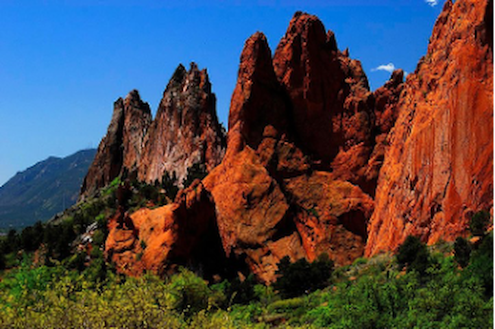
Directions: From I-25 take Exit 146 for Garden of the Gods Road.
The towering red rock formations of the Garden of the Gods Park are located at the base of Pikes Peak.
The Visitor and Nature Center and explore the geology, plants, animals and people of the 1,341.3-acre park, located at 1805 North 30th Street in Colorado Springs. This city-owned park is one of a kind. The site is a National Natural Landmark, having been recognized by the Department of the Interior as "a nationally-significant natural area." It offers towering sandstone formations, a wonderful view of Pikes Peak, paved and unpaved hiking paths, the historic Rock Ledge Ranch Historic Site, a living history museum, placed on the National Register for Historic Places in 1971, and many other amenities. The park was given to the city of Colorado Springs in 1909 by the children of railroad magnate Charles Elliot Perkins, in fulfillment of his wish that it be kept forever open and free to the public. As a result, this park can be enjoyed free of charge. Some activities and features include guided nature walks, hiking, mountain biking and horseback riding trails, road biking and technical rock climbing.
60 (рекомендации местных жителей)
Garden of the Gods Road
Garden of the Gods RoadDirections: From I-25 take Exit 146 for Garden of the Gods Road.
The towering red rock formations of the Garden of the Gods Park are located at the base of Pikes Peak.
The Visitor and Nature Center and explore the geology, plants, animals and people of the 1,341.3-acre park, located at 1805 North 30th Street in Colorado Springs. This city-owned park is one of a kind. The site is a National Natural Landmark, having been recognized by the Department of the Interior as "a nationally-significant natural area." It offers towering sandstone formations, a wonderful view of Pikes Peak, paved and unpaved hiking paths, the historic Rock Ledge Ranch Historic Site, a living history museum, placed on the National Register for Historic Places in 1971, and many other amenities. The park was given to the city of Colorado Springs in 1909 by the children of railroad magnate Charles Elliot Perkins, in fulfillment of his wish that it be kept forever open and free to the public. As a result, this park can be enjoyed free of charge. Some activities and features include guided nature walks, hiking, mountain biking and horseback riding trails, road biking and technical rock climbing.
It is the highest summit of the southern Front Range of the Rocky Mountains, in North America, and the Pikes Peak toll road runs right to the top. The Pikes Peak Highway was constructed in 1915 and financed by at a cost of $500,000. Downhill drivers have to check the brake temperatures of their vehicle at a midway check station and must have a low gear to go up. The highway has been home to an annual automobile and motorcycle race called the Pikes Peak International Hillclimb since 1916.
• Reservation: New for 2022, anyone wanting to drive their personal vehicle to the summit of Pikes Peak must make a timed-entry reservation.
• Fuel: There are no gas stations along the highway. You need at least 1/2 tank of gas before you start your scenic drive.
• Elevation gain: The highway's entrance begins at 7,400 feet and climbs to 14,115 feet to the summit of the mountain.
• Health: It is recommended if you have heart or respiratory issues to consult with your physician before visiting.
• Infants: Please no infants under 6 months old.
Food & Gift Shops
• The Crystal Reservoir Visitor Center is found just after mile marker 6. It's a good place to stop and grab a snack or purchase bait to go fishing. Ranger-led classes and paddle boat rentals are available in the summer months.
• Glen Cove Inn is found at mile marker 13, about half way up the mountain. Here you can find restrooms and a nice sit-down area with food for purchase.
• The Pikes Peak Summit Visitor Center sits at the top of Pikes Peak at 14,115 feet above sea level. Immerse yourself in the new interpretive experience or browse the extensive gift shop, use the restroom and grab some food. Options include salads, sandwiches and sides. Be sure to try the world-famous donuts, the only donuts made at an altitude over 14,000 feet. These donuts have special, high-altitude ingredients. So, make sure to eat these at the top of the mountain, as the change in altitude will change the texture of the donut.
Pikes Peak Photo Opportunities & Scenic Stops
• Definitely stop at Crystal Reservoir on your scenic drive up or down the Pikes Peak Highway. The water and peak create a perfect picturesque moment.
• Devils Playground also makes for a great stop to get out, walk around and take some beautiful photos.
• At the Summit Visitor Center, you'll want to take photos at the Summit Market or the dramatic north overlook near the edge where you can see for miles upon miles.
139 (рекомендации местных жителей)
Пайкс-Пик - Гора Америки
5089 Pikes Peak HwyIt is the highest summit of the southern Front Range of the Rocky Mountains, in North America, and the Pikes Peak toll road runs right to the top. The Pikes Peak Highway was constructed in 1915 and financed by at a cost of $500,000. Downhill drivers have to check the brake temperatures of their vehicle at a midway check station and must have a low gear to go up. The highway has been home to an annual automobile and motorcycle race called the Pikes Peak International Hillclimb since 1916.
• Reservation: New for 2022, anyone wanting to drive their personal vehicle to the summit of Pikes Peak must make a timed-entry reservation.
• Fuel: There are no gas stations along the highway. You need at least 1/2 tank of gas before you start your scenic drive.
• Elevation gain: The highway's entrance begins at 7,400 feet and climbs to 14,115 feet to the summit of the mountain.
• Health: It is recommended if you have heart or respiratory issues to consult with your physician before visiting.
• Infants: Please no infants under 6 months old.
Food & Gift Shops
• The Crystal Reservoir Visitor Center is found just after mile marker 6. It's a good place to stop and grab a snack or purchase bait to go fishing. Ranger-led classes and paddle boat rentals are available in the summer months.
• Glen Cove Inn is found at mile marker 13, about half way up the mountain. Here you can find restrooms and a nice sit-down area with food for purchase.
• The Pikes Peak Summit Visitor Center sits at the top of Pikes Peak at 14,115 feet above sea level. Immerse yourself in the new interpretive experience or browse the extensive gift shop, use the restroom and grab some food. Options include salads, sandwiches and sides. Be sure to try the world-famous donuts, the only donuts made at an altitude over 14,000 feet. These donuts have special, high-altitude ingredients. So, make sure to eat these at the top of the mountain, as the change in altitude will change the texture of the donut.
Pikes Peak Photo Opportunities & Scenic Stops
• Definitely stop at Crystal Reservoir on your scenic drive up or down the Pikes Peak Highway. The water and peak create a perfect picturesque moment.
• Devils Playground also makes for a great stop to get out, walk around and take some beautiful photos.
• At the Summit Visitor Center, you'll want to take photos at the Summit Market or the dramatic north overlook near the edge where you can see for miles upon miles.
Directions: North on I-25
Cheyenne is a little over an hour north of Denver and the capital and the most populous city of Wyoming. The climate is semi-arid with cold winters. The site was chosen as the point at which the Union Pacific Railroad crossed Crow Creek, a tributary of the South Platte River. Cheyenne is a friendly western town.
The Capitol building is renaissance revival architecture, and patterned after the National Capitol in Washington, D.C. The sandstone for the building came from a quarry in Rawlins, Wyoming. The 24-carat gold leaf dome is visible from all roads entering the city, and it has been gilded five times. While standing in the center of the rotunda, looking up directly overhead you see the stained glass, imported from England.
The Street Railway tours Cheyenne, Wyoming's Magic City of the Plains. The narrated tour departs from the historic Depot Building and takes you through Cheyenne's historic districts, providing a glimpse of the areas western & railroad heritage. It goes to the Wyoming State Capitol. It is said that the Depot and Capitol buildings face each other so they could keep an eye on each other! Built in 1886-1887 of locally quarried red and buff-colored sandstone blocks, it is self-proclaimed to be the most beautiful rail station in North America. This was the last of the grand 19th-century train depots built along the transcontinental railroad. The tower of the depot including the iron dome or cap is 128 feet in height, and rises over the north entrance of the arched open passage-way. With the exception of the capitol dome, it can be seen at a greater distance from Cheyenne than any other object in the city.
The Wrangler Building is a three-story red-painted brick building dominating a corner of Capitol Avenue by the train tracks. It has been home to some sort of retail outlet since its erection in 1892. The building has about 13,000 square feet of ranch wear and Western clothing. The sky-lit hat room has a selection of nearly 500 hats ranging in price from $12.99 to a $1,200 diamond-studded Stetson.
St. Mark's Episcopal Church of Cheyenne third tallest building in Cheyenne, was built in1888. The building stone is Castle Rock rhyolite and the interior is primarily oak wood resembling an upside-down ark (standard Episcopal) with marble floor. The inspiration for the design of St. Mark's church is said to be Stoke Poges Church outside of London.
Old West Museum – (A must do) Western Passenger Wagon circa 1865. It took 50 hours for this coach to travel distance of 300 miles from Cheyenne to Deadwood, Dakota Territory. Stops were made at stage stations ten miles apart to change horses and feed passengers.
The history of the world's largest outdoor rodeo and western celebration comes alive at the Cheyenne Frontier Days Old West Museum. A cultural and historical center, The Old West Museum offers exhibits and activities that celebrate the heritage and pioneer spirit of the American West and the history of the world's first extreme sport.
Lane Frost (1963 - 1989) was a professional bull rider, who died in the arena at the 1989 Cheyenne Frontier Days Rodeo as a result of injuries sustained riding the bull "Takin' Care of Business"
26 (рекомендации местных жителей)
Cheyenne
Directions: North on I-25
Cheyenne is a little over an hour north of Denver and the capital and the most populous city of Wyoming. The climate is semi-arid with cold winters. The site was chosen as the point at which the Union Pacific Railroad crossed Crow Creek, a tributary of the South Platte River. Cheyenne is a friendly western town.
The Capitol building is renaissance revival architecture, and patterned after the National Capitol in Washington, D.C. The sandstone for the building came from a quarry in Rawlins, Wyoming. The 24-carat gold leaf dome is visible from all roads entering the city, and it has been gilded five times. While standing in the center of the rotunda, looking up directly overhead you see the stained glass, imported from England.
The Street Railway tours Cheyenne, Wyoming's Magic City of the Plains. The narrated tour departs from the historic Depot Building and takes you through Cheyenne's historic districts, providing a glimpse of the areas western & railroad heritage. It goes to the Wyoming State Capitol. It is said that the Depot and Capitol buildings face each other so they could keep an eye on each other! Built in 1886-1887 of locally quarried red and buff-colored sandstone blocks, it is self-proclaimed to be the most beautiful rail station in North America. This was the last of the grand 19th-century train depots built along the transcontinental railroad. The tower of the depot including the iron dome or cap is 128 feet in height, and rises over the north entrance of the arched open passage-way. With the exception of the capitol dome, it can be seen at a greater distance from Cheyenne than any other object in the city.
The Wrangler Building is a three-story red-painted brick building dominating a corner of Capitol Avenue by the train tracks. It has been home to some sort of retail outlet since its erection in 1892. The building has about 13,000 square feet of ranch wear and Western clothing. The sky-lit hat room has a selection of nearly 500 hats ranging in price from $12.99 to a $1,200 diamond-studded Stetson.
St. Mark's Episcopal Church of Cheyenne third tallest building in Cheyenne, was built in1888. The building stone is Castle Rock rhyolite and the interior is primarily oak wood resembling an upside-down ark (standard Episcopal) with marble floor. The inspiration for the design of St. Mark's church is said to be Stoke Poges Church outside of London.
Old West Museum – (A must do) Western Passenger Wagon circa 1865. It took 50 hours for this coach to travel distance of 300 miles from Cheyenne to Deadwood, Dakota Territory. Stops were made at stage stations ten miles apart to change horses and feed passengers.
The history of the world's largest outdoor rodeo and western celebration comes alive at the Cheyenne Frontier Days Old West Museum. A cultural and historical center, The Old West Museum offers exhibits and activities that celebrate the heritage and pioneer spirit of the American West and the history of the world's first extreme sport.
Lane Frost (1963 - 1989) was a professional bull rider, who died in the arena at the 1989 Cheyenne Frontier Days Rodeo as a result of injuries sustained riding the bull "Takin' Care of Business"
Phantom Canyon has two tunnels hewn through the mountain, steep drop offs, blind curves, and gorgeous geology. Phantom Canyon is also one of the last remaining roadless canyons along Colorado's Front Range. The preserve provides habitat for many wildlife species, including black bear, mountain lion and bobcat. All three can be found on the Colorado species of special concern list. Phantom Canyon Road, a detour off the popular Gold Belt Tour scenic and historic byway in south-central Colorado, features green-spotted canyon walls and twisty turns lying on top of what was once a powerhouse railroad (the Florence and Cripple Creek Railroad) connecting the lucrative 1800s mining districts of Cripple Creek, Cañon City and Florence. Ghost towns of Wilbur, Adelaide and Glenbrook (to name a few) that washed away in flashfloods or dissipated as a result of the slowing economy after the railroad closed in 1912 are eerily present throughout. Some believe it’s named after an 1890s ghost sighting of a man wearing a prison uniform walking along the tracks. The passengers who spotted the man claim he was executed at the Colorado State Penitentiary a few days prior.
Engineers of narrow-gauge railroads like the Florence and Cripple Creek Railroad excelled at navigating sharp, narrow turns and steep, un-guarded drop-offs. As the road slowly gains in elevation from 5,500 to 9,500 feet, you’ll squeeze through two tunnels that were meticulously chiseled out of dense mountainous terrain by miners making room for a booming gold industry. Another sight to keep an eye out for is Adelaide Bridge, which spans Eight mile Creek. This steel architectural landmark is an official site of the National Register of Historic Places and is the only remaining bridge from the Florence and Cripple Creek Railroad.
15 (рекомендации местных жителей)
Phantom Canyon Road
Phantom Canyon RoadPhantom Canyon has two tunnels hewn through the mountain, steep drop offs, blind curves, and gorgeous geology. Phantom Canyon is also one of the last remaining roadless canyons along Colorado's Front Range. The preserve provides habitat for many wildlife species, including black bear, mountain lion and bobcat. All three can be found on the Colorado species of special concern list. Phantom Canyon Road, a detour off the popular Gold Belt Tour scenic and historic byway in south-central Colorado, features green-spotted canyon walls and twisty turns lying on top of what was once a powerhouse railroad (the Florence and Cripple Creek Railroad) connecting the lucrative 1800s mining districts of Cripple Creek, Cañon City and Florence. Ghost towns of Wilbur, Adelaide and Glenbrook (to name a few) that washed away in flashfloods or dissipated as a result of the slowing economy after the railroad closed in 1912 are eerily present throughout. Some believe it’s named after an 1890s ghost sighting of a man wearing a prison uniform walking along the tracks. The passengers who spotted the man claim he was executed at the Colorado State Penitentiary a few days prior.
Engineers of narrow-gauge railroads like the Florence and Cripple Creek Railroad excelled at navigating sharp, narrow turns and steep, un-guarded drop-offs. As the road slowly gains in elevation from 5,500 to 9,500 feet, you’ll squeeze through two tunnels that were meticulously chiseled out of dense mountainous terrain by miners making room for a booming gold industry. Another sight to keep an eye out for is Adelaide Bridge, which spans Eight mile Creek. This steel architectural landmark is an official site of the National Register of Historic Places and is the only remaining bridge from the Florence and Cripple Creek Railroad.
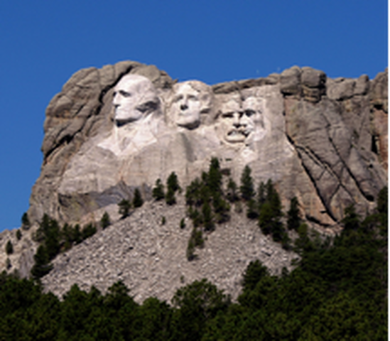
Directions: I-25- North to US-18 East to Mt Rushmore
There is so much to do in this area that you can spend as much time as you have. It is about 400 miles, a 6.5-hour drive.
Mount Rushmore National Memorial is centered on a sculpture carved into the granite face of Mount Rushmore in the Black Hills near Keystone, South Dakota.
The Crazy Horse Memorial is a mountain monument under construction on privately held land in the Black Hills, in Custer County, South Dakota.
Historic Deadwood, South Dakota is a city known for its gold rush history. Mount Moriah Cemetery has the graves of Wild West figures like Wild Bill Hickok and Calamity Jane.
Spearfish Canyon is a deep but narrow gorge carved by Spearfish Creek located in Lawrence County, South Dakota. Part of Dances With Wolves was filmed here.
Sturgis, SD -The Sturgis Motorcycle Rally is the largest motorcycle rally in the world. It is held annually in The Black Hills and in Sturgis, South Dakota for 10 days during the first week of August. It was started by local Indian dealer Pappy Hoel in 1938.
Red Cloud Indian School champions intellectual and spiritual growth, and Lakȟóta culture—language, ceremony, and visual arts—to create transformational opportunities for our Oglala Lakȟóta community.
Wounded Knee, located on the Pine Ridge Indian Reservation in South Dakota, was the site of conflict between North American Indians and the U.S. government. An 1890 massacre left 150 Native Americans dead, in the final clash between federal troops and the Sioux.
Delta-09 Minuteman Missile - From 1963 until the early 1990s, the missile silo contained a fully operational missile, bearing a 1.2 megaton nuclear warhead. The Delta-09 missile silo was one of 150 spread across western South Dakota. Tours daily.
Badlands National Park -This striking South Dakota landscape boasts a maze of buttes, canyons, pinnacles and spires. Skeletons of three-toed horses and saber-toothed cats are among the many fossilized species found here. Wildlife abounds in the park’s 244,000 acres and can often be seen.
35 (рекомендации местных жителей)
Mount Rushmore
Directions: I-25- North to US-18 East to Mt Rushmore
There is so much to do in this area that you can spend as much time as you have. It is about 400 miles, a 6.5-hour drive.
Mount Rushmore National Memorial is centered on a sculpture carved into the granite face of Mount Rushmore in the Black Hills near Keystone, South Dakota.
The Crazy Horse Memorial is a mountain monument under construction on privately held land in the Black Hills, in Custer County, South Dakota.
Historic Deadwood, South Dakota is a city known for its gold rush history. Mount Moriah Cemetery has the graves of Wild West figures like Wild Bill Hickok and Calamity Jane.
Spearfish Canyon is a deep but narrow gorge carved by Spearfish Creek located in Lawrence County, South Dakota. Part of Dances With Wolves was filmed here.
Sturgis, SD -The Sturgis Motorcycle Rally is the largest motorcycle rally in the world. It is held annually in The Black Hills and in Sturgis, South Dakota for 10 days during the first week of August. It was started by local Indian dealer Pappy Hoel in 1938.
Red Cloud Indian School champions intellectual and spiritual growth, and Lakȟóta culture—language, ceremony, and visual arts—to create transformational opportunities for our Oglala Lakȟóta community.
Wounded Knee, located on the Pine Ridge Indian Reservation in South Dakota, was the site of conflict between North American Indians and the U.S. government. An 1890 massacre left 150 Native Americans dead, in the final clash between federal troops and the Sioux.
Delta-09 Minuteman Missile - From 1963 until the early 1990s, the missile silo contained a fully operational missile, bearing a 1.2 megaton nuclear warhead. The Delta-09 missile silo was one of 150 spread across western South Dakota. Tours daily.
Badlands National Park -This striking South Dakota landscape boasts a maze of buttes, canyons, pinnacles and spires. Skeletons of three-toed horses and saber-toothed cats are among the many fossilized species found here. Wildlife abounds in the park’s 244,000 acres and can often be seen.
Directions: I-70- East to I-80 East to North Platte
North Platte, Nebraska is about 260 miles East and takes about 4 hours to get there. At the rest stop just West of town (about 10 miles) on the East bound side of the interstate, you can still see the wagon ruts from the Oregon Trail travelers. The wagon trains didn't follow the exact route - some places the trail is a hundred miles wide. Here the route was chosen to avoid the marshy ground along the North Platte River as they moved towards the South Pass to cross over the Continental Divide. This made the Oregon Trail width very narrow through this area. The trail ruts are 0.5 miles (0.80 km) long and are worn 2 to 6 feet into a sandstone ridge on the south side of the North Platte River. For me, this was a must see.
The Golden Spike Tower – all of the Union Pacific east/west trains are made here. The Eastbound Hump is 34’ tall. The Westbound Hump is 20’ tall. It is like a dance to watch them made and roll out. Be sure to catch the film on the orphan trains.
The Lincoln County Historical Museum
has the most wonderful film on the
North Platte Canteen. It was a railroad stop manned
by local citizens of North Platte, Nebraska, that
operated from Christmas Day 1941 to April 1, 1946,
and met EVERY train of soldiers coming through
with egg sandwiches, milk, candy, gum, cigarettes,
drinks, magazines, etc. Its purpose was to provide
refreshments and hospitality to soldiers who were
traveling through the area on the way to war during
their ten- to fifteen-minute stopovers. It was all
volunteer during a time of rations. From 1941-1946,
the canteen served 6 million troops. None of which,
were ever charged and no train was ever missed.
North Platte
Directions: I-70- East to I-80 East to North Platte
North Platte, Nebraska is about 260 miles East and takes about 4 hours to get there. At the rest stop just West of town (about 10 miles) on the East bound side of the interstate, you can still see the wagon ruts from the Oregon Trail travelers. The wagon trains didn't follow the exact route - some places the trail is a hundred miles wide. Here the route was chosen to avoid the marshy ground along the North Platte River as they moved towards the South Pass to cross over the Continental Divide. This made the Oregon Trail width very narrow through this area. The trail ruts are 0.5 miles (0.80 km) long and are worn 2 to 6 feet into a sandstone ridge on the south side of the North Platte River. For me, this was a must see.
The Golden Spike Tower – all of the Union Pacific east/west trains are made here. The Eastbound Hump is 34’ tall. The Westbound Hump is 20’ tall. It is like a dance to watch them made and roll out. Be sure to catch the film on the orphan trains.
The Lincoln County Historical Museum
has the most wonderful film on the
North Platte Canteen. It was a railroad stop manned
by local citizens of North Platte, Nebraska, that
operated from Christmas Day 1941 to April 1, 1946,
and met EVERY train of soldiers coming through
with egg sandwiches, milk, candy, gum, cigarettes,
drinks, magazines, etc. Its purpose was to provide
refreshments and hospitality to soldiers who were
traveling through the area on the way to war during
their ten- to fifteen-minute stopovers. It was all
volunteer during a time of rations. From 1941-1946,
the canteen served 6 million troops. None of which,
were ever charged and no train was ever missed.
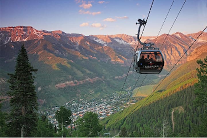
It is about a six-hour drive to the Mountain View/Telluride area on the Western range. This is a wonderful place to explore and spend a night or two. In my opinion, this is the most beautiful place I have seen. The Gondola between Telluride and Mountain Village is free. The Galloping Goose in Telluride is free transpiration. The elevation is high.
If you have the time, take one of the six-wheel tours up to the 13,000 ft. Imogene Pass through the ghost town of TomBoy. The one lane road was blasted into the side of the mountain – it is an amazing trip.
From the city park you can hike to little bear falls or take the longer hike to black bear falls.
The town of Telluride has its own resident Elk herd.
Don’t miss the museum in Telluride – it has a wonderful history Telluride, mining and the Tomboy mine.
The stretch of road between Silverton to Ouray is the Million Dollar Highway. Legend has it that it took a million dollars to build the road. Another legend has it when the road was paved it covered over a million dollars’ worth of gold. Colorado's Million Dollar Highway is often considered one of the greatest drives in the world and a ride everyone should experience once. It provides some of the best views imaginable.
Ouray is a historic town with natural hot springs to soak in. Burros wander free.
Box Canyon Waterfall & Park - Waterfalls cascade through canyon walls at this park near Ouray.
Alchemist Pharmacy Museum - Take a guided tour back in time to experience pharmacy in the Wild West.
Wiesbaden Hot Springs Spa - A spa sitting on a natural hot spring that provides visitors with a full range of spa activities or simply the chance to soak.
Million Dollar Highway
Million Dollar HighwayIt is about a six-hour drive to the Mountain View/Telluride area on the Western range. This is a wonderful place to explore and spend a night or two. In my opinion, this is the most beautiful place I have seen. The Gondola between Telluride and Mountain Village is free. The Galloping Goose in Telluride is free transpiration. The elevation is high.
If you have the time, take one of the six-wheel tours up to the 13,000 ft. Imogene Pass through the ghost town of TomBoy. The one lane road was blasted into the side of the mountain – it is an amazing trip.
From the city park you can hike to little bear falls or take the longer hike to black bear falls.
The town of Telluride has its own resident Elk herd.
Don’t miss the museum in Telluride – it has a wonderful history Telluride, mining and the Tomboy mine.
The stretch of road between Silverton to Ouray is the Million Dollar Highway. Legend has it that it took a million dollars to build the road. Another legend has it when the road was paved it covered over a million dollars’ worth of gold. Colorado's Million Dollar Highway is often considered one of the greatest drives in the world and a ride everyone should experience once. It provides some of the best views imaginable.
Ouray is a historic town with natural hot springs to soak in. Burros wander free.
Box Canyon Waterfall & Park - Waterfalls cascade through canyon walls at this park near Ouray.
Alchemist Pharmacy Museum - Take a guided tour back in time to experience pharmacy in the Wild West.
Wiesbaden Hot Springs Spa - A spa sitting on a natural hot spring that provides visitors with a full range of spa activities or simply the chance to soak.
Neighborhoods
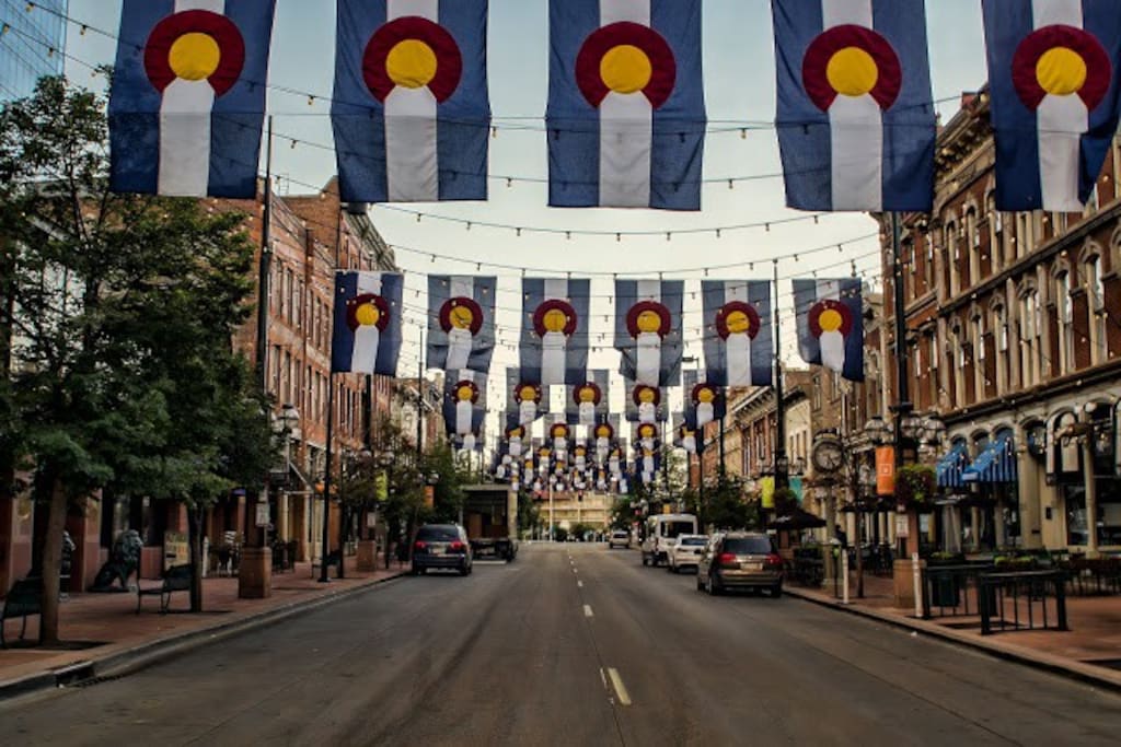
LoDo
Lower Downtown Denver, CO
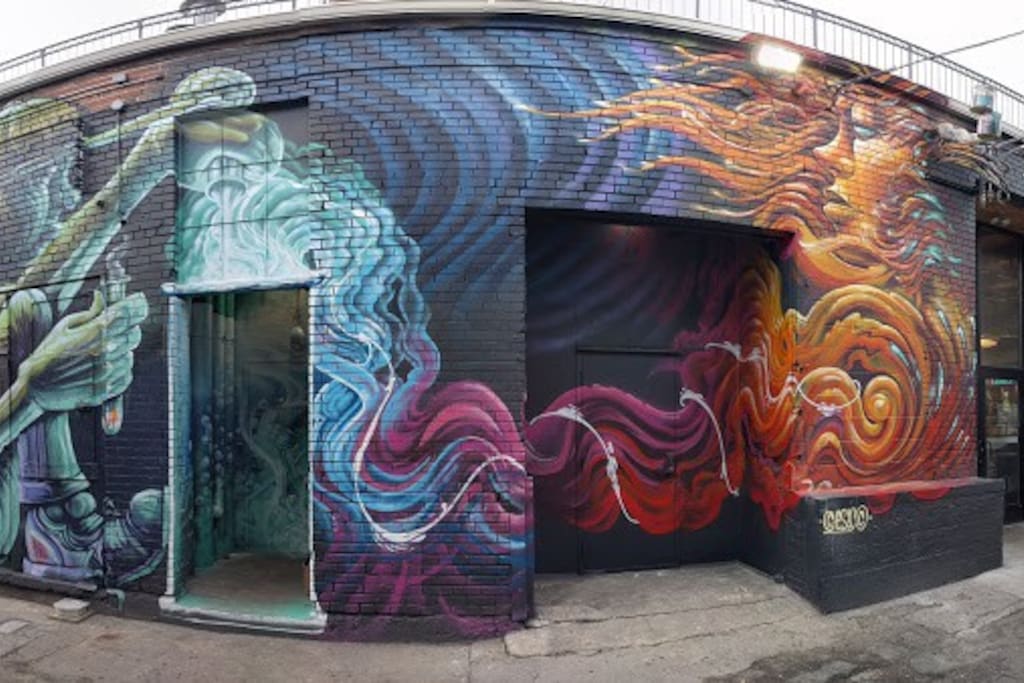
Район искусств Ривер-Норт
Food scene
3 Margaritas Southlands
25791 East Smoky Hill RoadGood Mexican Food
Ted's Montana Grill
11950 Bradburn BlvdGreat Steaks and Buffalo Meatloaf.
Рекомендации для путешественников
Транспорт
Regional Transportation District (RTD), metro Denver
It's easy to get from Denver International Airport (DEN) to downtown Denver on the airport rail line. At a cost of $10.50, travelers can use the A Line to get from the airport to downtown Denver and vice versa, courtesy of the Regional Transportation District (RTD), metro Denver's public transit provider.
The A Line, whisks travelers to downtown, specifically Denver Union Station , which is the city's transportation hub. From Union Station, travelers can access additional local and regional transportation services, such as light rail, regional and local buses, Amtrak rail service, taxis and t